


la Cadière la lougne

Marcsaintcyr
User
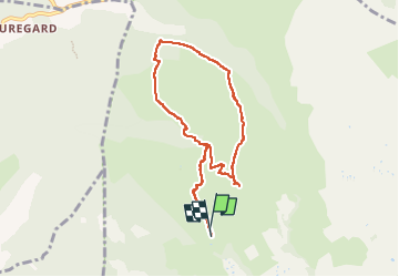

Length
8.3 km

Max alt
434 m

Uphill gradient
308 m
Km-Effort
12.4 km

Min alt
164 m

Downhill gradient
314 m
Boucle
Yes
Creation date :
2023-04-03 12:00:54.402
Updated on :
2023-04-03 15:00:25.017
2h58
Difficulty : Medium

FREE GPS app for hiking
 SityTrail
IGN / Geographical institutes
SityTrail Plus
The world is yours!
About
Trail Walking of 8.3 km to be discovered at Provence-Alpes-Côte d'Azur, Var, La Cadière-d'Azur. This trail is proposed by Marcsaintcyr.
Positioning
Country:
France
Region :
Provence-Alpes-Côte d'Azur
Department/Province :
Var
Municipality :
La Cadière-d'Azur
Location:
Unknown
Start:(Dec)
Start:(UTM)
718896 ; 4787618 (31T) N.
Comments